Saint Kitts Water Services Department Employs Semi-Airborne Drone Survey to Bolster Water Security
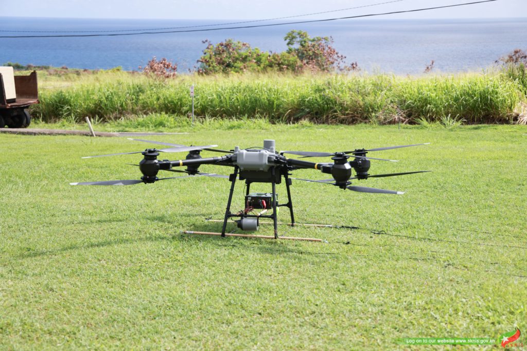
The Water Services Department (WSD) in Saint Kitts and Nevis has embarked on a groundbreaking initiative to bolster the twin-island nation’s water security through a comprehensive semi-airborne drone survey. This technologically advanced approach marks a significant step towards optimizing water management practices and ensuring the long-term sustainability of the federation’s water resources. The drone survey, utilizing cutting-edge LiDAR (Light Detection and Ranging) technology, will provide detailed, high-resolution data on the island’s topography, vegetation, and infrastructure, enabling the WSD to develop a more accurate and comprehensive understanding of the water cycle within the specific context of Saint Kitts. This detailed information will be crucial for informed decision-making regarding water resource allocation, infrastructure development, and proactive measures to mitigate the impacts of climate change and other environmental pressures.
The semi-airborne drone survey represents a significant leap forward from traditional surveying methods. Conventional ground surveys, while valuable, can be time-consuming, labor-intensive, and often limited in their scope, particularly in challenging terrains. The drone-based approach overcomes these limitations by providing rapid, wide-area coverage with unparalleled accuracy. The high-resolution data captured by the LiDAR sensors allows for the creation of highly detailed 3D models of the terrain, enabling precise mapping of water bodies, watersheds, and other critical features. This level of detail empowers the WSD to identify potential vulnerabilities within the water supply system, assess the impact of land use changes on water resources, and develop targeted strategies for water conservation and management. Furthermore, the survey will facilitate the creation of a comprehensive digital twin of the island’s water infrastructure, enabling more efficient maintenance and proactive planning for future expansions or upgrades.
The data gathered from the semi-airborne drone survey will be instrumental in informing a range of crucial water management initiatives. By precisely mapping the island’s water sources, including rivers, reservoirs, and groundwater aquifers, the WSD can develop a more accurate assessment of the available water resources and their distribution. This information is vital for planning the sustainable allocation of water for various uses, such as domestic consumption, agriculture, and industry, ensuring equitable access for all sectors while preserving the ecological balance. Furthermore, the detailed topographical data will be used to model water flow patterns and predict the potential impacts of extreme weather events, such as floods and droughts, allowing for the development of proactive mitigation strategies and enhanced disaster preparedness.
The drone survey plays a pivotal role in enhancing the resilience of Saint Kitts and Nevis’ water infrastructure to the growing challenges posed by climate change. Rising sea levels, increasingly erratic rainfall patterns, and the heightened risk of extreme weather events pose significant threats to the island’s water security. The precise data obtained through the survey will enable the WSD to identify vulnerable areas within the water supply system and implement targeted measures to enhance their resilience. This includes assessing the potential impacts of saltwater intrusion on coastal aquifers, developing strategies to minimize water loss due to evaporation and leakage, and optimizing the design and placement of future water infrastructure to minimize the risks associated with climate change impacts.
The WSD’s adoption of this advanced technology underscores the government’s commitment to leveraging innovation for sustainable development. The investment in the semi-airborne drone survey is not simply a technological upgrade but a strategic investment in the long-term water security and overall resilience of Saint Kitts and Nevis. The data generated will provide a foundation for evidence-based decision-making in water resource management, enabling the development of sustainable policies and strategies to ensure the continued availability of clean, reliable water for future generations. This proactive approach to water management aligns with the global push towards sustainable development goals and demonstrates the government’s dedication to safeguarding the island’s precious natural resources.
Beyond the immediate benefits for water management, the data collected through the drone survey has the potential to provide valuable insights for a range of other sectors. The high-resolution topographical information can be utilized for urban planning, disaster risk assessment, environmental monitoring, and even agricultural development. This cross-sectoral application of the data maximizes the return on investment and highlights the potential of innovative technologies like LiDAR to contribute to broader societal benefits. The semi-airborne drone survey, therefore, represents a significant step towards a more sustainable and resilient future for Saint Kitts and Nevis, demonstrating the transformative power of technology in addressing the challenges of a changing world.
Share this content:








Post Comment